---------- Forwarded message ---------
From: Léa Lacroix <lea.lacroix@wikimedia.de>
Date: Mon, Dec 10, 2018 at 8:23 AM
Subject: [Wikidata] Miniature map for coordinate properties
To: Discussion list for the Wikidata project. <wikidata@lists.wikimedia.org>
From: Léa Lacroix <lea.lacroix@wikimedia.de>
Date: Mon, Dec 10, 2018 at 8:23 AM
Subject: [Wikidata] Miniature map for coordinate properties
To: Discussion list for the Wikidata project. <wikidata@lists.wikimedia.org>
Hello all,
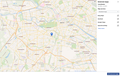
After we deployed the Commons miniature pictures for the image properties, some editors suggested to do something similar with maps. >From Wednesday, December 12th, we will also have a miniature map displayed for the properties containing coordinates, like coordinate location (P625). This feature uses mw:Extension:Kartographer and OpenStreetMap.
Viewing the map directly in the item will help the editors to check quickly if the coordinates seem correct, and therefore improve the data quality.

View in read mode

View in edit mode
Full screen with list of external maps

Some useful features:
- Double-click on the miniature map: display it in full screen
- On full screen view: click on “external maps” to display different map services and links to many external maps
- In edit mode: when adding or editing coordinates in the field, the maps is automatically updated to fit the coordinates you entered
- The coordinates are still displayed under the map and link to Geohack
If you have any questions or issues with this feature, let me know. You can also see the related ticket.
Cheers,--
Léa Lacroix
Project Manager Community Communication for Wikidata
Wikimedia Deutschland e.V.
Tempelhofer Ufer 23-24
10963 Berlin
www.wikimedia.de
Wikimedia Deutschland - Gesellschaft zur Förderung Freien Wissens e. V.
Eingetragen im Vereinsregister des Amtsgerichts Berlin-Charlottenburg unter der Nummer 23855 Nz. Als gemeinnützig anerkannt durch das Finanzamt für Körperschaften I Berlin, Steuernummer 27/029/42207.
Wikidata mailing list
Wikidata@lists.wikimedia.org
https://lists.wikimedia.org/mailman/listinfo/wikidata